Summit Aconcagua
Trip Information
Argentina is the second largest country in South America and the eighth
largest in the world. Argentina occupies a continental surface area of
1,068,302 sq miles between the Andes mountain range in the west and the
southern Atlantic Ocean in the east and south. It is bordered by
Paraguay and Bolivia in the north, Brazil and Uruguay in the northeast,
and Chile in the west and south. Argentina also claims 374,312 sq miles
of Antarctica, known as Argentine Antarctica. The climate of Argentina
is classified as temperate.
Mendoza
Mendoza is located in the northern-central part of the province, in a
region of foothills and high plains, on the eastern side of the Andes.
As of 2001 Mendoza's population was 110,993. The metropolitan population
was 848,660 in 2001, making Greater Mendoza the fourth largest census
metropolitan area in the country. Mendoza was founded in 1561 by Pedro
del Castillo. Before this time it was populated by three tribes, the
Huarpes, the Puelches, and the Incas. The Huarpes devised a system of
irrigation that was later developed by the Spanish. This allowed for an
increase in population that might not have otherwise occurred. The
system is still evident today in the wide trenches that run parallel to
the city streets. It is estimated that less than 80 Spanish settlers
lived in the area before 1600, but later prosperity increased due to the
use of indigenous and slave labor. The temperature in December and
January ranges from highs of 90 to lows of 64.
The Mountain
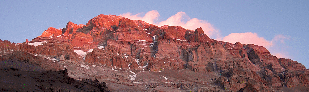
Cerro Aconcagua is the highest mountain in the Americas, and the highest
mountain outside Asia. It is located in the Andes mountain range, in the
Argentine province of Mendoza. The summit is located about 5 kilometers
from San Juan Province and 15 kilometers from the international border
with Chile. It lies 112 km (70 mi) west by north of the city of Mendoza.
Aconcagua is bounded by the Valle de las Vacas to the north and east and
the Valle de los Horcones Inferior to the West and South. The mountain
has a number of glaciers. The most substantial are the north-eastern or
Polish Glacier and the eastern or English Glacier. The origin of the
name is contested, it is either from the Arauca Aconca-Hue, which refers
to the Aconcagua River and means 'comes from the other side' or the
Quechua Ackon Cahuak, meaning 'Sentinel of Stone'.
The mountain has two summits - North (22,841 ft. 6962 meters) and South
(22,736 ft. 6930 meters), joined by a ridge (Cresta del Guanaco),
pictured to the right, approximately one kilometer long. Various ridges
radiate from each summit and the whole massif is isolated from other
high peaks. Only to the northwest is it connected by a high snow ridge
with the surrounding mountain systems. The usual approach is from the
south up the Quebrada de los Horcones, which circles the western flanks
of the peak, to the Plaza de Mulas base camp. From here 3 routes start:
the Normal, will be the route we are taking, via the Horcones Glacier
Superior and north ridge, the West Buttress route, and the South-West
route.
Climbing History
The first ascent of Aconcagua was led by the English alpinist Edward
Fitz Gerald, during the summer of 1897. Fitz Gerald's group acceded to
the stony slope of the Northwest side of the mountain after following
upstream the Horcones River. After several tries, the Swiss teammate
Mathias Zurbriggen reached the summit alone on the 14th of January,
1897. This was followed a few days later by Nicholas Lanti and Stuart
Vines, members of the same expedition, made the second climb following
the same route. The youngest person to reach the summit of Aconcagua was
Jordan Romero of Big Bear Lake, California. He was 11 years old when he
reached the summit on December 30, 2007.
Geology
The height of Aconcagua is not a result of active volcanoes such as Mt.
Tupungato, rather the elevation is caused by the tectonic lifting of the
mountain range. The tectonic characteristics are controlled by the
interaction of the Nazca and South American plates, and the geometry of
the zone of subduction. The glacial action was much more active in the
past and the rock forms that resulted from this action are now found
modified by the action of the other processes mainly mass removal and
the actions of the rivers. The glaciations in the principal pre-mountain
range don't reach the level of the glaciers of Patagonia due to more
arid conditions and intense tectonic activity. The action of the ice
took the form of the valley glaciations, forming caps in the high
mountain only united at the highest elevations, such as Aconcagua, Plomo
Juncal, and the Ramada Range. In the area around Aconcagua one finds a
series of glaciers including the Lower Glacier Horcones that have their
birth at the foot of Mt Aconcagua and the Upper Horcones. We travel
through this valley and the presence of the moraine is still evident
until base camp. A famous geologist, Espizua (1993), described the
Horcones drift as: "a current of ice some 50 meters thick occupied the
valleys of the Lower Horcones Rivers and the Upper Horcones, extending
for 20 kilometers from Mt. Aconcagua as far as the Puente del Inca (Inca
Bridge), at 2750 meters, where it finds the last moraine."
Your Guide
Each climb is led by the Climb Leader with a maximum of 3:1 ratio. The
climb leader is responsible for overseeing all aspects of the climb and
looks after the physical well-being of the crew.
Your Crew
On Aconcagua we will have a large support crew assisting us to the
summit. Included are:
Mules: We have a pack of mules to carry our equipment to our first and
second camp. The mules are a very important part of our climb and offer
great support with logistic transfers and evacuations.
Porters: Included are a team of porters to carry all of our personal and
expedition equipment to each of the high camps. Our porters will take
over after camp (2) and carry the load up to the high camps.
Camp Staff: We will have group dining in the first two camps with our
second camp offering a variety of meals in Plaza de Mulas. After we
depart for our high camps we will have a crew cooking all our meals to
ensure we have the energy on our summit bid.
Your Team on the Ground
The operations base for the climb is Mendoza and Plaza de Mulas, AR.
Your guide leader will have constant contact with both bases during
various periods of the expedition. The base team is responsible for the
logistics of operating on the mountain and ensures that the equipment
used is clean and in good condition. The operating team works closely
with your team and is responsible for handling all transfers, meal
preparation, porter coordination, and accommodations. Each climb is run
with process checks and quality management built in to ensure a safe and
enjoyable experience.
Normal Route
The normal route along the Northwest Ridge is a non-technical, however,
a physically demanding climb that involves all the logistics of climbing
a big mountain. The ascent does require mountaineering skills such as
the use of crampons and trekking at high altitude. Our route begins at
Plaza de Mulas located at the end of the Horcones Valley. We will
utilize three higher camps, Canada 4,907 m (16,200 ft.), Nido de
Condores 5,395 m (17,500 ft.) and Colera 5,861 m (19,200 ft.) to obtain
our summit.
Weather
Aconcagua, like all big mountains, attracts and generates its own
weather patterns making it very difficult to predict. Be prepared for
freezing nights, snowy and windy conditions, bright sunshine, and plenty
of variety. Because our climb is late in the season we should expect to
see large snowfields at the high camps. Aconcagua is located at 32
degrees 39 minutes south, the same distance from the equator as San
Diego, California. The best time to climb the mountain is from
December—March but the chance of storms during these months still exists
due to moist humid winds blowing from the west off of the Pacific Ocean.
As this humid air rises over the slopes of the Andes, its speed
increases and it condenses to form lenticular clouds on the summit.
Generally, winds from the south are a sign of good weather and enable us
to go for a successful summit bid.
What to Expect on the Mountain
Each morning our team will be up at a reasonable hour, have a good
breakfast, and begin our activity for the day. Some days we will arrive
early and have a chance to relax at our site. We will be issued a bag
from the ranger station for our waste, as well as our permit, which we
will need to have on our person at all times.
Transportation
Air Travel:
Please make flight arrangements to fly into Mendoza, Argentina (airport
code MDZ). LAN and American Airlines have the most direct flights
through Santiago with a connecting flight to Mendoza. Please make your
departure arrangements for an evening departure out of Mendoza since the
majority of international flights leave after 9pm out of Santiago,
Chile. If you elect to get a direct flight to Santiago, Chile and take a
bus transfer over the mountains please be aware you will be required to
pay a reciprocity charge passing through immigration. It is recommended
that all participants book flights that can be changed in the event we
exit the mountain earlier than expected.
Ground Transfers:
Included in your program are private transfers from the airport to the
hotel, to and from the mountain, back to Mendoza and then to the airport
after the climb. The vehicles are van style and have plenty of capacity
for our team as well as our equipment we are taking to Confluencia. For
transfer around the city there are several taxis available if you would
like to explore the city reaches. Taxis are inexpensive but it is
recommended to have pesos to pay for the taxi in order to get an
accurate rate. For those who are traveling in via the bus route we will
have a guide meet you at the terminal and transfer you to the hotel. All
transfers are with insured and certified vehicles approved by our
organization.
Helicopter Transfers:
After our summit bid we will stay one additional night at our high camp
before transferring back to base camp at Refugio Plaza de Mulas. The
following morning we will have the opportunity to descend via helicopter
to the trail head and have a view of your route from above. The
helicopter is an Ecureuil AS-350-B3. The single engine AS350 Ecureuil is
renowned for its altitude performance and its safety. The AS350 B3 is
"the high performance" version of the single engine Ecureuil range.
Powered by a Turbomeca Arriel 2B turbine engine it is equipped with the
FADEC system. It is totally suited for operations in conditions such as
mountainous areas, hot countries or for very demanding missions,
performance wise. The helicopter will be optional for anyone who wishes
to depart this way. The other option is to hike the 17 miles back to the
Horcones trail head. The team departing by foot will leave around 8 am
and the team departing by air will leave around 2pm. We will all meet at
the park entrance before heading back to Mendoza as a group.
Mule Services:
We will have mules carrying our equipment from the trail head to
Confluencia and then from Confluencia to Plaza de Mulas. The mules can
carry 132 lbs (60 kg) each. All our food will be provided at the camps
and the majority of the high altitude equipment resides at our elevated
base camp. We have mules to transfer our equipment back to the trail
head on our descent enabling us to carry minimal weight for a speedy
exit. On our descent from base camp the mules will depart at 10am from
base camp. Mules are also available to ride out if you have, or
encounter, knee trouble or other physical injury that may make your
descent difficult. We can arrange this transfer for you prior to the
program departure.