Mt Whitney Challenge
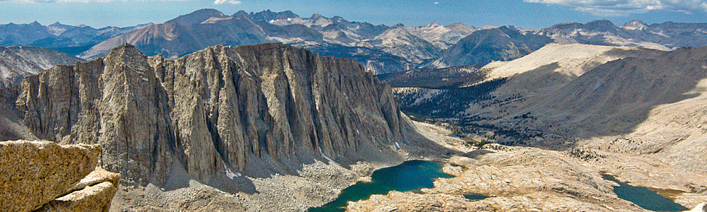
Mount Whitney is the highest mountain in the
contiguous United States with an elevation of 14,505 feet (4,421 m). It
is located at the boundary between California's Inyo and Tulare
counties. The western slope of the mountain lies within Sequoia National
Park and the summit is the southern terminus of the John Muir Trail. The
peak was named after Josiah Whitney, the State Geologist of California.
Mount Whitney is just 76 miles (122 km) west of the lowest point in
North America at Badwater in Death Valley National Park (282 feet (86 m)
below sea level), and can be seen from points within the park,
atmospheric conditions permitting.
First Ascent
As soon as Clarence King discovered Mount Whitney from the summit of Mt.
Tyndall in 1864, the race was on to be the first to climb it. King
attempted the summit in 1871, with a small grant of $100, and reached
the peak in a severe storm reducing the visibility of the surrounding
peaks, but was confident he had reached the summit of Whitney. As it
turned out King, and his partner Paul Pinson, had climbed Mt. Langley
and was forced to make another summit attempt of Whitney on September
19, 1873. They did succeed, however the peak had already been reached by
the “Fishermen”: John Lucas, Charles Begole, and Albert H. Johnson on
August 20, 1873. All members of the party were from the Owens Valley
Region and due to their primary professions as fishermen the peak was
attempted to be renamed “Fishermen’s Peak”. Even with the first ascent
by a group of Fishermen the name proposed by William Brewer nine years
before after the California Geologist Josiah Whitney remained.
Geology
The summit lies along the Sierra Crest and near many of the highest
peaks of the Sierra Nevada. Water that falls to the west of the crest
flows into the Pacific Ocean and that to the east flows into the Great
Basin. The eastern slope of Whitney is much steeper than the western
slope mainly because the entire Sierra Nevada is a result of a fault
block that is analogous to a door: the door is hinged on the west and is
slowly rising to the east. The granite that forms Mount Whitney is part
of the Sierra Nevada batholiths. In Cretaceous time masses of molten
rock that originated from subduction rose underneath what is now Whitney
and solidified underground to form large expanses of granite. In the
last few million years the Sierra started to uplift enabling glacial and
river erosion to strip the upper layers of rock to reveal the resistant
granite that makes up Mount Whitney today.
Geography
The peak rises 10,778 feet (3,285 m) or just over two miles above the
town of Lone Pine in the Owens Valley below. The estimated elevation of
the summit of Mount Whitney has changed over the years. This is not due
to the peak growing (although it is). The technology of elevation
measurement has become more refined and, more importantly, the vertical
coordinate system has changed. The peak was commonly said to be at
14,494 feet (4,418 m) and this is the elevation stamped on the USGS
brass benchmark disk on the summit. An older plaque on the summit (sheet
metal with black lettering on white enamel) reads "elevation 14,496.811
feet" but this was estimated using the older vertical datum from 1929.
Since then the shape of the Earth (the geoid) has been estimated more
accurately. Using a new vertical datum established in 1988 the benchmark
is now estimated to be at 14,505 feet (4,421 m).